Street maps, extracts from Ordnance Survey maps etc. of Cowbridge and the surrounding area.
Bonvilston & Llantrithyd map 1914
Map of Cowbridge borough
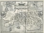
Map of Glamorgan, 1610
Cowbridge, Llanblethian & Penlline parishes...
Cowbridge & Llanblethian Dunraven estate ca...
Cowbridge OS map of 1972
Yates' map of Glamorgan 1799
Vale of Glamorgan map 1787
OS map of Cowbridge 1919
Land ownership maps, Cowbridge and around
Cowbridge burgage plots and town walls
Cowbridge shops at 1989
Cowbridge street map 1980s
Cowbridge and environs map 1922
Map of Glamorgan by Christopher Saxton ca 1584
Map of Glamorgan by Lawrence Nowell ca 1570
Map of Glamorgan by Peter Keer ca 1620
Map of Glamorgan south by Humphrey Lhuyd 1573
Map of Glamorgan by Christopher Saxton 1578
Map of Glamorgan by Saxton and Lee 1693
Tithe map 1843 of Westgate, Cowbridge
Tithe map 1843 of Eastgate, Cowbridge
Tithe map 1843 of Eastgate and the Limes,...
Tithe map 1843 of High Street, Cowbridge
Street map of High Street, Cowbridge 1972