Content can be downloaded for non-commercial purposes, such as for personal use or in educational resources.
For commercial purposes please contact the copyright holder directly.
Read more about the The Creative Archive Licence.


Description
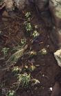
Picture: 1
St Mary's Well Bay
More vegetation where white lias slabs interleaved with shales which weather to soil. St Mary's Well Bay. Note loss of most of the brick building on cliff top. January 1983
Date: January 1983
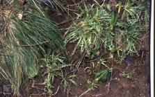
Picture: 2
St Mary's Well Bay to Swanbridge. Triass cliffs and vegetation
Aquifer at junction of Triassic tea green and red marls. Water supports Enteromorpha, St Mary's Well
Picture: 3
St Mary's Well Bay to Swanbridge. Triass cliffs and vegetation
Alabaster nodule holes (potato stones) St Mary's Well Bay
Picture: 4
St Mary's Well Bay to Swanbridge. Triass cliffs and vegetation
Whita Lias slab full of fossil oysters. St Mary's Well Bay. NB in Rhaetic sea invaded Trias salt lakes so marine
Picture: 5
St Mary's Well Bay
Cliff West of St Mary's Well Bay, East of Swanbridge
Picture: 6
Swanbridge and Sully Bay to Sully Hospital
Hard calcite bandsat right angles to Trias beds, St Mary's Well Bay 1973
Date: 1973
Picture: 7
Swanbridge and Sully Bay to Sully Hospital
Tabular white Lias and black shales of Rhaetic. Tea green marls of Trias below. St Mary's Well Bay West of Lavernock syncline, January 1983
Date: January 1983


Do you have information to add to this item? Please leave a comment
Comments (0)
You must be logged in to leave a comment